
News
Wireless Festival boss defends Kanye West appearance
BBC News
We're going to see the warmest weather of the year so far across the UK through this week.
Widely temperatures will rise to the high teens to low twenties over the next few days with 24C expected in south-east England.
There'll be lots of dry and sunny weather to go with it too.
By Thursday colder air will spread in from the north-west with temperatures returning to around the average.
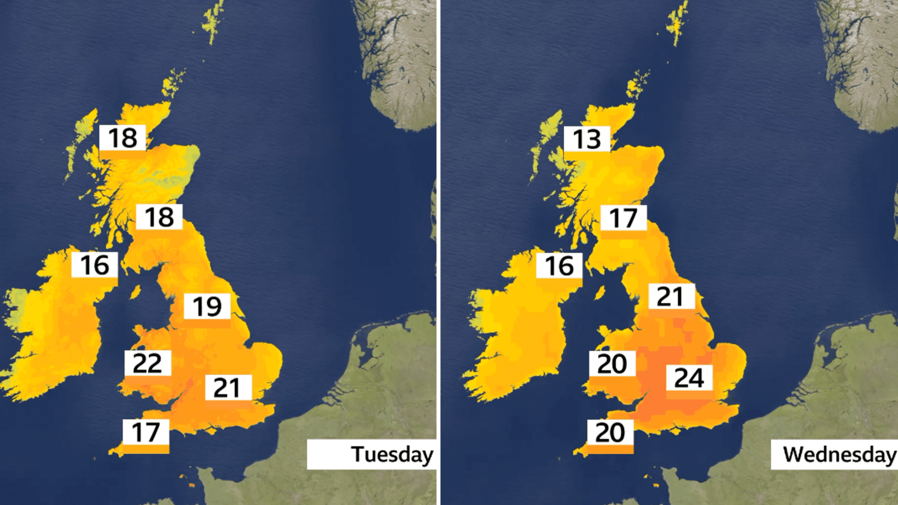
Image caption,
Temperatures on Tuesday and Wednesday set to rise well above average for early April
Brisk south-easterly winds developing on Tuesday and Wednesday will drag in much warmer air from the European continent.
Temperatures will be around 6 to 10C above average for early April.
On Tuesday temperatures will rise to the high teens and low twenties in most parts.
Across the south Midlands and the west coast of Wales it is likely to reach 22C, making it the warmest day of the year so far.
The previous highest temperature this year was 20.9C, recorded on 31 March at Pershore, Worcestershire.
Tuesday will be a mostly sunny day, especially across England and Wales but cloud will build in Northern Ireland and western Scotland with a few showers.
By Wednesday temperatures will rise even further to 23C, perhaps even 24C in south-east England.
With sunshine continuing, temperatures across England and Wales will still be into the low twenties, so it will feel more like a typical summer's day for most of us.
However, conditions will turn a little cooler in western Scotland, Northern Ireland and Irish Sea coasts with more cloud and rain moving in later in the afternoon.
With a change to the weather patterns on Thursday, the warmer south-easterly wind will be replaced by a cooler north-westerly.
Temperatures will therefore noticeably drop to around 10 to 14C across most areas.
But, while cooler in eastern and south-eastern England on Thursday, it will still be around 17C here.
Though these temperatures are more typical for the time of year.
Thursday will also see a spell of rain spreading south eastward across the UK before it clears away from the south-east later in the day.
High pressure nudges back in on Friday to bring a mostly dry and bright day.

Image caption,
Sunrise or sunset might become more colourful this week as Saharan dust gets transported to the skies above the UK
Heat will also build this week in western Europe with temperatures rising well above average.
In France some locations could see a temperature approaching 30C but it'll also be very warm in northern Spain and western Germany reaching the high twenties.
These temperatures will be around 8 to 12C above the average for early April.
Forecasts are also showing dust whipped up in North Africa could be transported high in the atmosphere across western Europe this week.
The increased dust is also likely to spread into parts of the UK from late on Tuesday.
When you have more dust particles suspended high in the atmosphere, it can make our sunrise and sunsets more colourful.
Share this article
Temperatures are expected to reach the warmest levels of the year so far across the UK. Most places will see high teens to low twenties, with up to 24C possible in south-east England.
Tuesday is expected to be the warmest day of the year so far for many areas. Temperatures could reach 22C in the south Midlands and west coast of Wales, and even higher on Wednesday in some places.
Brisk south-easterly winds are bringing much warmer air from the European continent. This is expected to push temperatures around 6 to 10C above average for early April.
Cooler air is expected to move in from the north-west on Thursday. Temperatures should drop back to around 10 to 14C across most areas, which is closer to the seasonal average.
Yes, dust from North Africa may spread into parts of the UK from late Tuesday. It could make sunrises and sunsets look more colourful because dust particles high in the atmosphere scatter the light.


See every story in News — including breaking news and analysis.